Abridged History of the District and Ochre Arch (to assist readers in understanding the lead-up to the present land conditions)
We are of the view that the first Aboriginal contact with the area we today call Ochre Arch occurred 31,000 years ago (unproven) and that prior to then there had been no human influence on the property. Our search of local history records reveal that Ochre Arch first came under some form of European influence in 1839 when the grazing property known as “Pinnacle Run” (26,880 acres) was gazetted. The local township of Grenfell was gazetted in 1866. In 1899 what we now call Ochre Arch (953 acres) became part of a 1,587 acre property which was resumed (with 3 other properties) out of “Pinnacle Run”. We assume that this was when the first serious land clearing efforts for cropping commenced as by 1909 it was reported that 200 acres of the 1,587 acres property had been planted to wheat and that more land was being cleared. By 1934 the area of our farm reduced to what it is today. We also assume that cropping and grazing have historically been the two main income generating activities, although it’s feasible that timber from the property may have been a source of revenue when it was originally felled.
Local Climate
The average annual rainfall at Ochre Arch is around 600 mm per annum (slightly less than Grenfell at 626 mm) and records for the area show that the distribution is reasonably even throughout the year, although of course the effectiveness varies greatly with the season. Number of rain days each month peak during the winter months. The environment is ‘tending brittle’ at around 6-6.5 (out of 10).
The mean daily year round maximum temperatures at Grenfell is 22.3 degrees C, and the mean daily minimum is 9.3 degrees C. During the summer months maximum temperatures have been known to be as high as 44 degrees C (January), and fall to as low as -8 degrees C in unusual years during winter.
Land Monitoring Methodology
The monitoring methodology we will be using will be more or less in line with the guidelines set out in the ‘Holistic Management Handbook – Healthy Land, Healthy Profits’ written by Jody Butterfield, Sam Bingham and Allan Savory and published in 2006. You will find a copy of the handbook’s Table of Contents here.
Our intention is to track the condition of the land and ground cover at 3 levels:
1. Above ground condition – essentially tracking the change in the species composition over time.
2. Ground surface condition – primarily percentage ground cover. Many experts argue that this is the most critical lead indicator as the ground surface is very much the ‘gateway’ to all that occurs underneath ground level.
3. Below ground condition – there is a range of simple tests we will carry out, but we are also hoping that recent discussions with Charles Sturt University bear fruit and we have an Honours student or two studying and recording changing in the volume and mix of soil organisms.
Site Photographs and Selection Criteria
Photographs of each of the sites appear below, together with some of the supporting logic (to us, anyway!) in site selection. Two steel posts 30 metres apart in an east/west direction (so that shadows don’t become a problem when taking photos down the track) mark each of the sites. Each of the photographs was taken over the top of one of the 2 posts and all of them were taken looking in an easterly direction.
Site 1 – Forgotten Paddock
The Forgotten Paddock is located on the western side of Ochre Arch and aeolian (wind blown) soil over granite. The site is near the northern fence-line in this paddock.
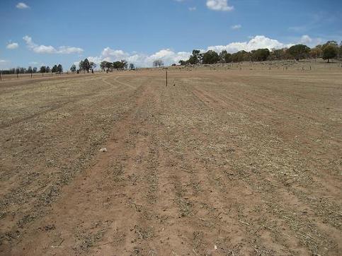
We chose this location given the westerly aspect (land slopes gently down from east to west) of the land, ease of access, recent cropping history with application of inorganic fertilisers, and the fact that we are aiming for the creation of healthy pasture in the area.
In 2006 the paddock was sown to oats, with 100 kg /ha of diammonium phosphate (DAP) fertiliser applied. Wheat was also sown in 2005. Ground cover is virtually non-existent, consisting basically of a light amount of straw and some sheep manure.
Site 2 – Contour Paddock
The Contour Paddock is located on the northern side of Ochre Arch and is on aeolian soil. The site is to the south of what we call the Crayfish Dam. We chose this location given the northerly aspect (land slopes down from south to north) of the land, its extremely poor condition due to erosion, coupled with our desire to use a range of natural techniques to rehabilitate the whole area.

The site is within the catchment to the Crayfish Dam - which has always (to our knowledge) had water containing very high clay content. At one stage the land was being farmed (inorganic fertilisers applied) but this is not the case today as the topography is too steep and almost all of the top (and in some cases sub) soil has been washed away. Many locals refer to this type of land a ‘scorched’. In time our goal is to restore this site to healthy pasture, and it may even transpire that the water flow into the dam loses the bulk of the clay content i.e. it becomes pretty much (if not totally) clear.
The Contour Paddock has been in a regular cropping rotation but it is now 2 to 3 years since the paddock was in crop. There is no ground cover on the land in the monitoring site, although there is some sheep manure which we expect will be lost (most likely into the dam) in the event of a heavy downpour.
Site 3 – Plateau Paddock
The Plateau Paddock is located on the eastern side of Ochre Arch and is on granite based geology. The site is just to the east of the highest point in the paddock – a gently sloping convex fully cleared peak. We chose this location given the easterly aspect (land slopes down from west to the east) of the land, ease of access, recent cropping history with application of inorganic fertilisers, it is near the top of a hill making it different to the other sites, and we are aiming for the creation of healthy pasture in the area.
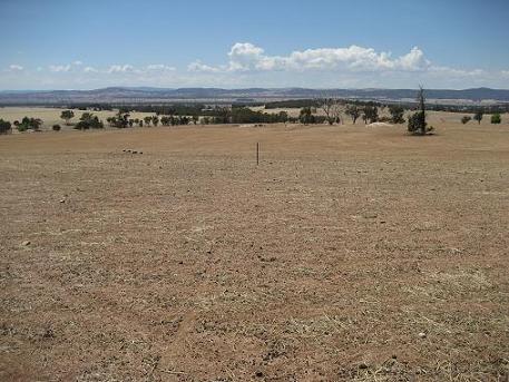
In 2006 the paddock was sown to wheat, with 100 kg /ha of diammonium phosphate (DAP) fertiliser applied. Wheat was also sown in this paddock in 2005. Ground cover is virtually non-existent, consisting basically of a light amount of straw and some sheep manure.
Site 4 – Native Pasture Paddock
The Native Pasture Paddock is located on the southern side of Ochre Arch and is on granite based geology. The paddock was progressively cleared between around 1965 – 1986 and was previously box / gum country. There were one or two attempts to sow cereal crops and non-native pasture species in the early to mid 1980’s but this proved non-viable due to the high incidence of sharp sticks and stump residuals in the soil, leading to several punctured tractor tires.
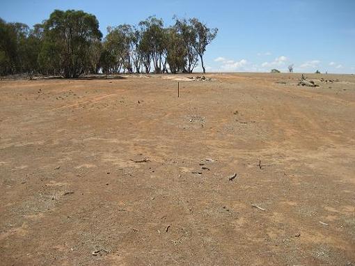
The site is just to the south of the northern fence-line across a gently sloping depression or gully. Most of the water that will run through this depression from time to time will run off the Plateau Paddock to the north. We chose this location given the southerly aspect (land slopes down from north to south) of the land, it is across a gully giving a different aspect to the other sites, has virtually no cropping history or application of inorganic fertilisers, and the predominant grass species are native to the area. We are aiming to create healthy pasture in the area.
There is very little ground cover on this land, although there are the remnants of some native pasture species coupled with a smattering of dried sheep manure.
Additional Monitoring Sites
We may create another site in one of the two woodland paddocks on Ochre Arch. This is where less grazing will occur and where the bulk of the tree and natural rock shelter areas are. We will be managing these paddocks for both conservation and pasture production and would monitor in accordance with the guidelines set out in the “Grassy Ecosystem Management Kit – A Guide to Developing Conservation Management Plans”. There is a lot of work involved in this type of monitoring, including monitoring wildlife, and we’d be delighted if someone or group was prepared to voluntarily take on the responsibility for us (hint, hint to anyone who has the interest and would be prepared to take on the challenge!).
Timing of the Land Monitoring
Our intention is to carry out the first lot of monitoring at next verdancy – mid spring 2007, and at least annually thereafter. If anyone is interested in voluntarily assisting us in the process we’d love to hear from you! Just send me an email at pdiprose@optusnet.com.au.
Grenfell district at the time (and subsequent) of European settlement
More information on the Grenfell district at the time of European settlement & subsequent is in the following blog: http://ochrearchives.blogspot.com/2007/03/grenfell-district-in-early-european.html
No comments:
Post a Comment